Crooked Bush by Dean Jarvey / CC BY 2.0
In Saskatchewan you’ll find beautiful prairies, dense forests, some badlands, plenty of lakes and rivers, and even some impressive sand dunes. Most of the province’s population lives in the southern portion, where the landscape is mostly prairie. The northern half is densely forested with little population and development. On this page you’ll find details of many of the best places to photograph in Saskatchewan.
The interactive map below shows the locations mentioned on this page. We plan to continue to update the page in the future, so feel free to leave a comment with your own suggestions about other locations that you think should be added.
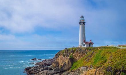
Prince Albert National Park
Prince Albert National Park is in central Saskatchewan about 90 km north of the town of Prince Albert. The park is accessible by Highways 2, 240, 263, and 264. The roads are to the east and southeast ends of the park. The town of Waskesiu is within the park, on the shore of Waskesiu Lake. This area is home to most of the accommodations and facilities within the park. Most visitors stay here due to the accommodations and access to trails and other activities.
Scenic Route 263 provides plenty of great views of the landscape, and access to several lakes. South of Waskesiu Lake, The Narrows Road is another great drive.
Wildlife in the park includes moose, elk, deer, foxes, black bears, coyotes, and more.
Prince Albert National Park by Kyla Duhamel / CC BY 2.0
Narrow Hills Scenic Drive, Narrow Hills Provincial Park
Narrow Hills Provincial Park is east of Prince Albert National Park. This beautiful park includes several lakes, boreal forest, and narrow valleys. The 19 km Narrow Hills Scenic Drive provides beautiful views of the lakes and forests (high clearance or 4-wheel-drive vehicle recommended).
Nipekamew River and Nipekamew Sand Cliffs
The Nipekamew Sand Cliffs are in central Saskatchewan, northeast of Prince Albert National Park. Highway 165 provides access to the area. The sand cliffs were formed by erosion of the Nipekamew River. A 1.5 km trail provides views of the sand cliffs from across the river.
Nipekamew River by tsaiproject / CC BY 2.0
Grasslands National Park
Grasslands National Park is in southern Saskatchewan, along the U.S. border (north of Montana). This prairie grasslands region is home to wildlife like pronghorn, bison, brown bears, coyotes, and more. The park is divided into east and west blocks. The west block can be accessed from the town of Val Marie, and it features a herd of bison and the Frenchman River Valley. The east block is accessible south of the town of Wood Mountain. This side is more wilderness, but provides excellent views of the Kildeer Badlands. The hoodoos of the Valley of 1000 Devils in the east block is a picturesque highlight of the park.
Grasslands National Park by Edna Winti / CC BY 2.0
Great Sand Hills
The Great Sand Hills are in southwestern Saskatchewan, southeast of the town of Leader. When you think of the Canadian landscape, sand dunes may not be the first thing that comes to mind. The Great Sand Hills cover almost 2,000 square kilometers and are quite impressive. There are roads around the edges of the Great Sand Hills in a few different areas, but the roads near the town of Sceptre (close to Leader) are a popular access point.

Great Sand Hills by Drm310 / CC BY-SA 4.0
Castle Butte and the Big Muddy Badlands
The Big Muddy Badlands are in southern Saskatchewan along the Big Muddy Creek. Castle Butte is a sandstone formation about 70 meters high. It is located along Highway 34 about 20 km south of the town of Bengough. Badlands tours are available from the town of Coronach.

Castle Butte by Grahampurse / CC BY-SA 4.0
Cypress Hill Interprovincial Park, Conglomerate Cliffs
Cypress Hill Interprovincial Park covers is in southwestern Saskatchewan and southeastern Alberta. In addition to the part of the park that straddles the border, there is also another section in Saskatchewan west of Highway 21. The Cypress Hills includes forest, grassland, prairie, streams, and lakes. It is the highest elevation in Saskatchewan.
A highlight for photographers is the Conglomerate Cliffs, which rise above Adams Lake (near the Fort Walsh Historical Site). These beautiful rock formations are perfect for being photographed.

Cypress Hills Interprovincial Park by Erik Lizee / Public Domain
Avonlea Badlands
The Avonlea Badlands are located outside the town of Avonlea in southern Saskatchewan. This rugged landscape is on private property and not all that well known. Guided walking tours are available through the Avonlea Heritage Museum.
Jones Peak
Jones Peak is in southwestern Saskatchewan, near the town of Eastend in the Frenchman River Valley. From Jones Peak you have a great view of the river valley. A steep gravel road leads the way to the peak, which starts from Middle Bench Road. A 4-wheel-drive vehicle is recommended.
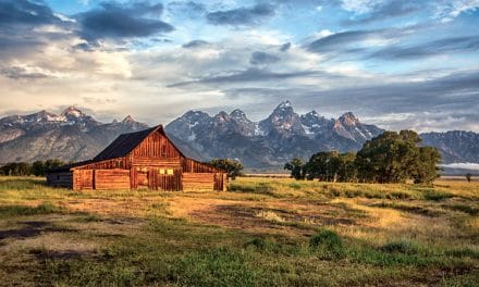
Lake Diefenbaker
Lake Diefenbaker is a man-made lake and reservoir created by the construction of two dams. It is more than 200 km long with over 800 km of shoreline. It is in southern Saskatchewan, south of Saskatoon. Multiple parks are located around Lake Diefenbaker, including three provincial parks. This is a popular recreational area that has a lot to offer.
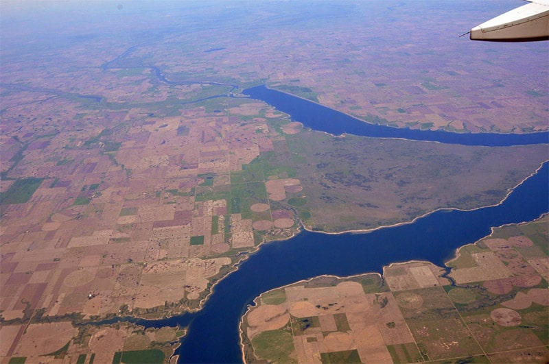
Lake Diefenbaker by Abdallahh / CC BY 2.0
Luck Lake
Luck Lake and the town of Lucky Lake are very close to Diefenbaker Lake. This is a great place to view wildlife, especially migratory birds and waterfowl. Highway 45 and grid road 646 provide road access to the Luck Lake Heritage Marsh, with a hiking trail available.
Skull Canyon
Skull Canyon is a beautifully rugged, and very remote, canyon on the Clearwater River in western Saskatchewan. The canyon features steep cliffs and amazing views. The only way to access the area is by canoeing the river. Tours are available, but the trip can be long (a week or two, depending on how far you are traveling) and challenging. Clearwater River Provincial Park protects the area, but it is a wilderness park with no facilities and very limited road access. Highway 955 is the only road in the park. Smoothrock Falls, upstream of Skull Canyon, is also very picturesque.
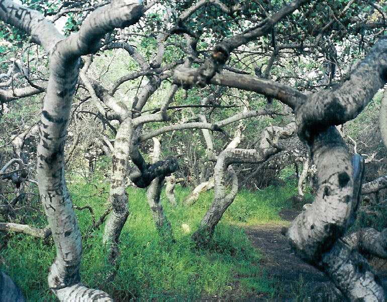
Crooked Bush
The Crooked Bush (also known as Crooked Trees and Twisted Trees) are near the town of Alticane, northwest of Saskatoon. It is a grove of aspen trees with an unusual deformation that is likely the result of genetic mutation. There is a wooden walkway leading through the grove.
Crooked Bush by Dean Jarvey / CC BY 2.0
Duck Mountain Provincial Park
Duck Mountain Provincial Park is in southeastern Saskatchewan, very close to the Manitoba border. It is home to boreal forest and several lakes. Madge Lake is the largest lake in the park and a hub of activity. Highway 57 provides access to the park and to Madge Lake. This is a separate, unconnected park from Manitoba’s Duck Mountain Provincial Park.
Athabasca Sand Dunes
The Athabasca Sand Dunes are in northwest Saskatchewan along Lake Athabasca. They are the most northerly sand dune formation on earth. Athabasca Sand Dunes Provincial Park protects the dunes and provides access. The dunes are about 100 km long, with a maximum height of 30 meters. This is a wilderness location that can only be reached by boat or float plane. There are no roads and no facilities within the park.
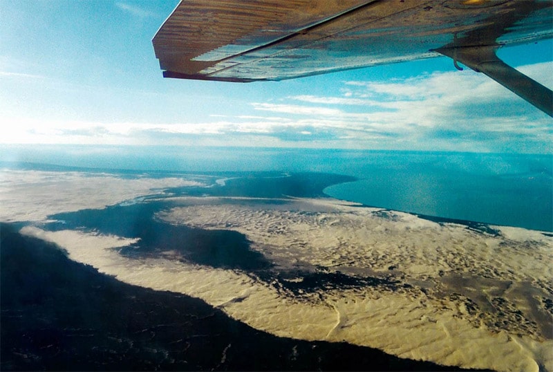
Athabasca Sand Dunes by Tim Beckett / CC BY 2.0
Hunt Falls
Hunt Falls (also known as Lefty Falls) is in northern Saskatchewan on Grease River, before it flows into Lake Athabasca. This very wide waterfall is Saskatchewan’s biggest, and is certainly a beautiful site. Very few people visit, due to its remote location. The best way to reach hunt falls is by landing a float plane above the falls on Eagle Rock Lake. A short walk will lead to nice views of the falls.
Broadway Bridge
The Broadway Bridge is a picturesque arch bridge in the city of Saskatoon, south central Saskatchewan. It spans the South Saskatchewan River.
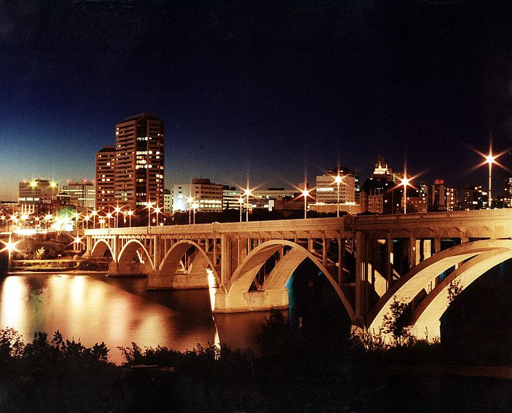
Broadway Bridge by Jay Van Doornum / CC BY-SA 2.5
Photo license links: CC BY 2.0, CC BY-SA 4.0, CC BY-SA 2.5