View of Sugarloaf Mountain by Zoe Rudisill / CC BY 2.0
With its access to the Great Lakes, Michigan is full of natural beauty that is perfect for the landscape photographer. Shorelines, cliffs, waterfalls, and more are abundant on both the Lower and Upper Peninsulas. On this page you’ll find details of many of the best places to photograph in Michigan. The interactive map below shows the location of each spot mentioned on this page.
This page will continue to be a work in progress, so please feel free to leave a comment with your own suggestions of great places to photograph.
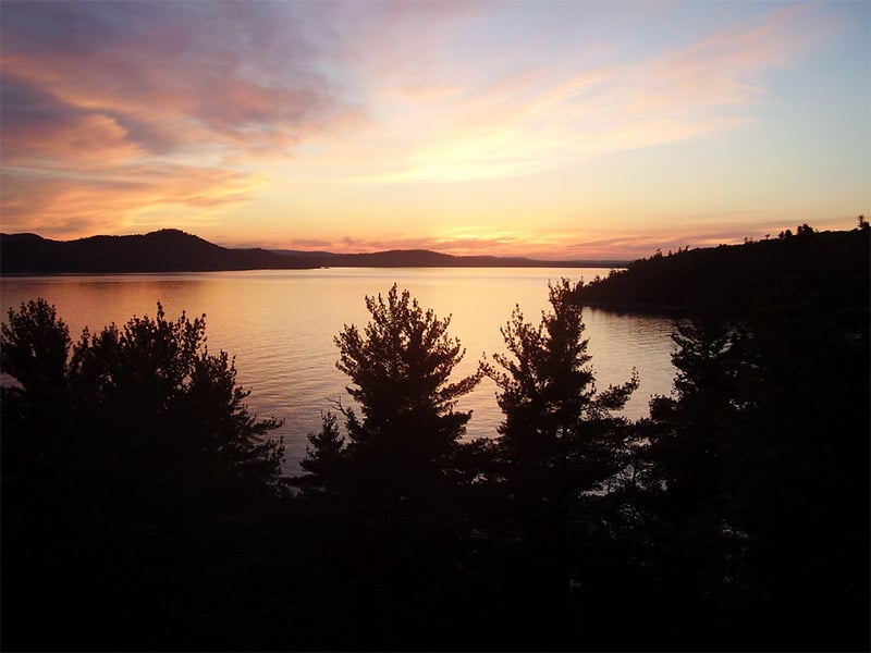
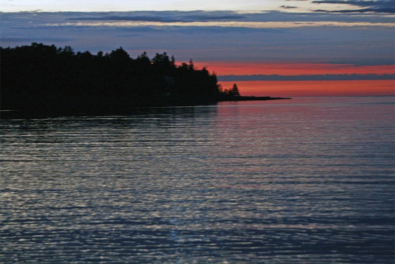
Isle Royale National Park
Isle Royale is an island on Lake Superior right at the border between the United States and Canada. The entire island, as well as some adjacent islands, make up Isle Royale National Park. The island is 45 miles long and 9 miles wide at its widest point. To access this island park you will need to take a ferry, seaplane, or a private boat. Ferries are available from Copper Harbor, Michigan and Grand Portage, Minnesota. Due to the location and difficulty of reaching the park it totally closes from November 1st through April 15th.
Because it is only open seasonally and because it is not easily accessible, Isle Royale is one of the least-visited national parks in the United States. Despite the fact that visitor numbers are low, the park and landscape are beautiful. This also means that it is possible to get unique photos. There are two main developed parts of the island. Windigo is where ferries from Minnesota will arrive. Rock Harbor is where ferries from Michigan will arrive. Both areas have accommodations, and several wilderness campsites are available throughout the park.
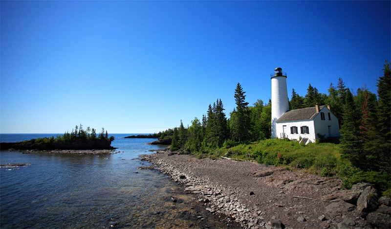
Isle Royale National Park by Ray Dumas / CC BY-SA 2.0
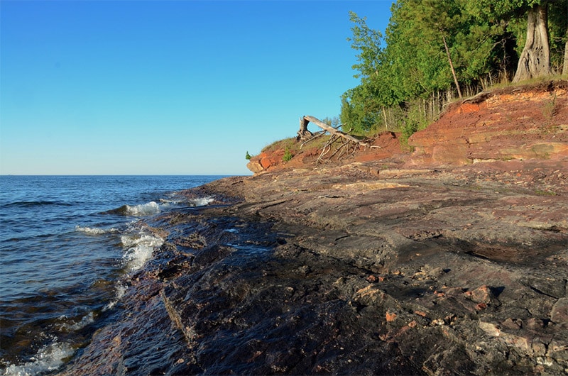
Pictured Rocks National Lakeshore
Pictured Rocks National Lakeshore is located on Michigan’s Upper Peninsula on the southern shores of Lake Superior. It includes more than 40 miles of beautiful shorelines that feature amazing rock formations, cliffs, natural archways, and waterfalls. The cliff walls reach up to 200 feet above the lake. This is a great destination to get amazing photos a unique and beautiful landscape.
The area can be accessed from the towns of Munising (west) and Grand Marais (east). Roads from each end enter the park, but there are few areas where road lead to lake access. Many parts of the lakeshore can be accessed by hiking or guided cruises during summer months.
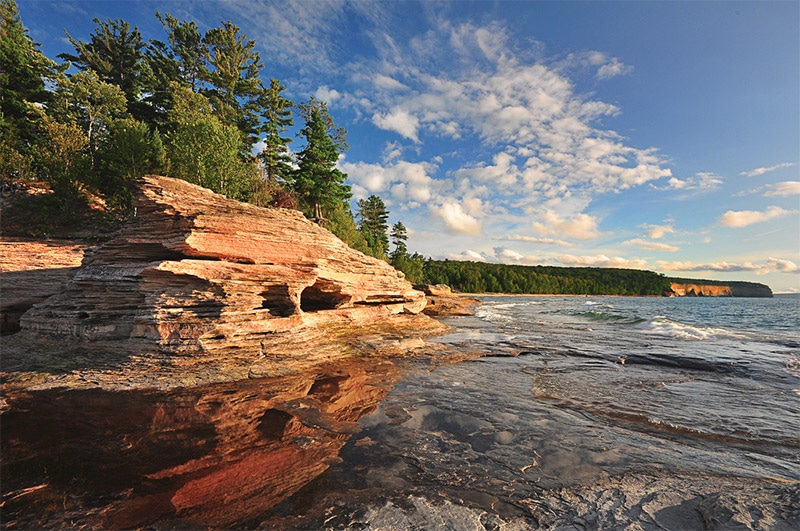
Pictured Rocks National Lakeshore by Mark Stacey / CC BY 2.0
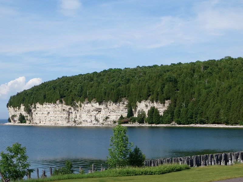
Sleeping Bear Dunes National Lakeshore
Sleeping Bear Dunes National Lakeshore is on the northwestern Lower Peninsula of Michigan. It includes 35 miles of shoreline on Lake Michigan. It also includes North Manitou Island and South Manitou Island. Here you will find bluffs that reach 450 feet above the lake, sand beaches, dunes, and forests. The area is pretty easy to access and most of the main attractions are reachable by road. The park’s website has some helpful information about getting around.
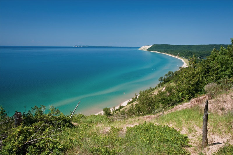
Sleeping Bear Dunes National Lakeshore by Rod / CC BY-ND 2.0
Tahquamenon Falls State Park
Tahquamenon Falls State Park is on the Upper Peninsula bordering on Lake Superior. The Tahquamenon River runs through the park, and one of the main features is Tahquamenon Falls. The upper falls is a single 50-foot drop. The lower falls consists of several smaller cascades. The upper falls can be easily accessed from the park’s visitor’s center, but much of the rest of the park is undeveloped. There are more than 20 miles of hiking trails for exploring.
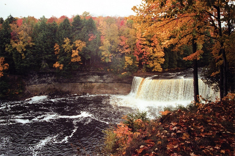
Tahquamenon Falls State Park by Dawn Endico / CC BY-SA 2.0
Ludington State Park
Ludington State Park is on the western side of the Lower Peninsula on the shores of Lake Michigan. The park also includes Hamlin Lake. The park features sand dunes, forests, and plenty of beautiful lake scenery.

Ludington State Park by Doug Coldwell / CC BY-SA 3.0
Porcupine Mountains Wilderness State Park
Porcupine Mountains Wilderness State Park is on the western side of the Upper Peninsula along Lake Superior. The park is home to stunning old growth hardwood forest, lakes, and rivers. Some of the park is accessible by road, but you’ll need to hike to get the most out of your time in this wilderness area.
Porcupine Mountains State Park by Jim Sorbie / CC BY 2.0
Wilderness State Park
Wilderness State Park is located on the northern edge of the Lower Peninsula. Within the park Waugoshance Point juts out into Lake Michigan. As you might guess from the name Wilderness State Park, much of the park is not accessible by car. There are more than 20 miles of hiking trails that lead to plenty of great scenery.
Wilderness State Park by Scot Martin / CC BY-ND 2.0
St. Joseph Lighthouse
St. Joseph is located on southwestern Michigan on the shores of Lake Michigan. The town’s lighthouse is frequently photographed, and winter photos of the ice-covered lighthouse have often made their way around the internet.
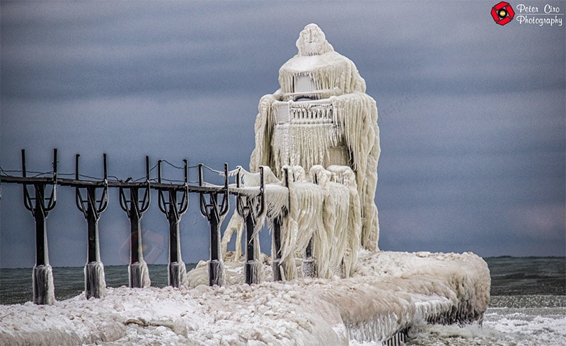
St. Joseph Lighthouse by Peter Ciro / CC BY-ND 2.0
Presque Isle Park
Presque Isle Park is on Michigan’s Upper Peninsula on the shores of Lake Superior. The 300-acre park is on a peninsula that juts out into the lake and offers beautiful nature. The park is easily access by car from the town o Marquette.
Presque Isle Park by Woody Hibbard / CC BY 2.0
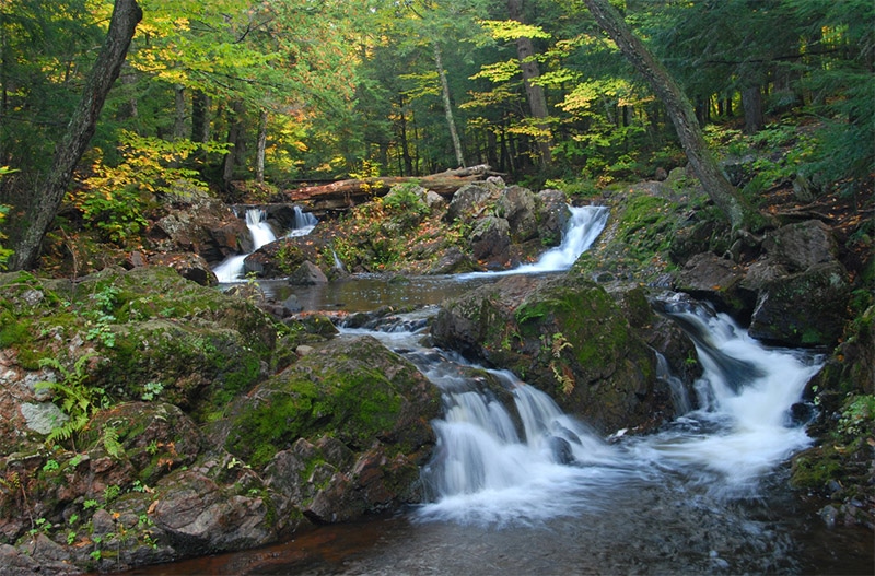
Bond Falls State Scenic Site
Bond Falls State Scenic Site is on the western side of the Upper Peninsula. Bond Falls is a beautiful 50-foot waterfall. You can easily get to the waterfall by using U.S. Highway 45. There is a parking area with a trail that leads to the falls, with a bridge over the river providing a great view of the falls.
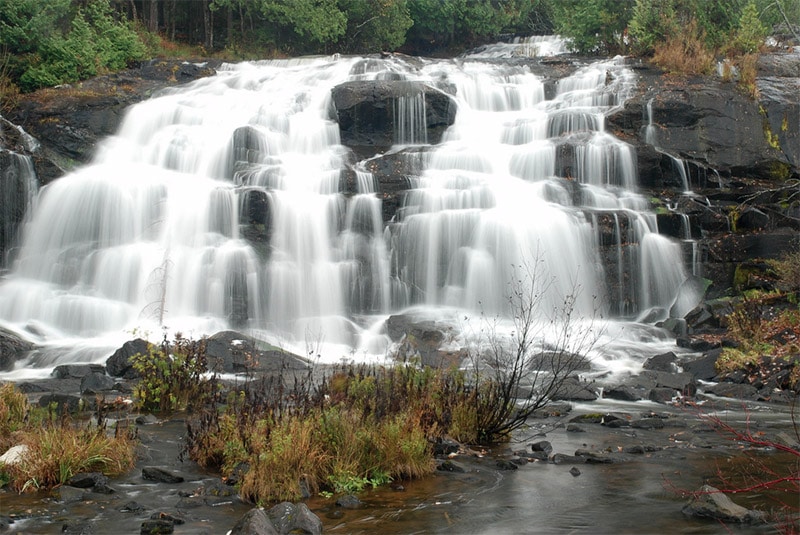
Bond Falls by Tony Faiola / CC BY 2.o
Fayette State Historic Park
Fayette State Historic Park is on the south side of Michigan’s Upper Peninsula on the shores of Lake Michigan. The town of Fayette was an industrial community in the 1800’s and now sits as a re-constructed historic site. Aside from the history, the park is also home to some beautiful scenery. The park features about 8 miles of hiking trails that provide access to impressive dolomite cliffs and hardwood forests.
Fayette State Historic Park by Rachel Kramer / CC BY 2.0
Seney National Wildlife Refuge
Seney National Wildlife Refuge is in the central part of Michigan’s Upper Peninsula. This wetlands area is bordered by state highways 28 and 77. The refuge is mainly set up to protect birds, but it is also home to black bears, moose, wolves, and other animals. The 7-mile Marshland Wildlife Drive is open from May 15th through October 20th. It leads through the wetlands and forests with observation decks.

Seney National Wildlife Refuge by John and Karen Holligsworth / Public Domain
Hiawatha National Forest
The Hiawatha National Forest covers nearly 900,000 acres on Michigan’s Upper Peninsula. It includes shorelines of three different Great Lakes: Lake Superior, Lake Michigan, and Lake Huron. It is separated into east and west units, with the west unit bordering Pictured Rocks National Lakeshore. This national forest features rivers, lighthouses, and shoreline.
Hiawatha National Forest by Bob Nichols / CC BY-ND 2.0
Wagner Falls State Scenic Site
Wagner Falls is south of Munising and near Pictured Lakes National Lakeshore and Hiawatha National Forest. This picturesque cascading waterfall can be accessed with just a short half-mile trail from the parking lot.
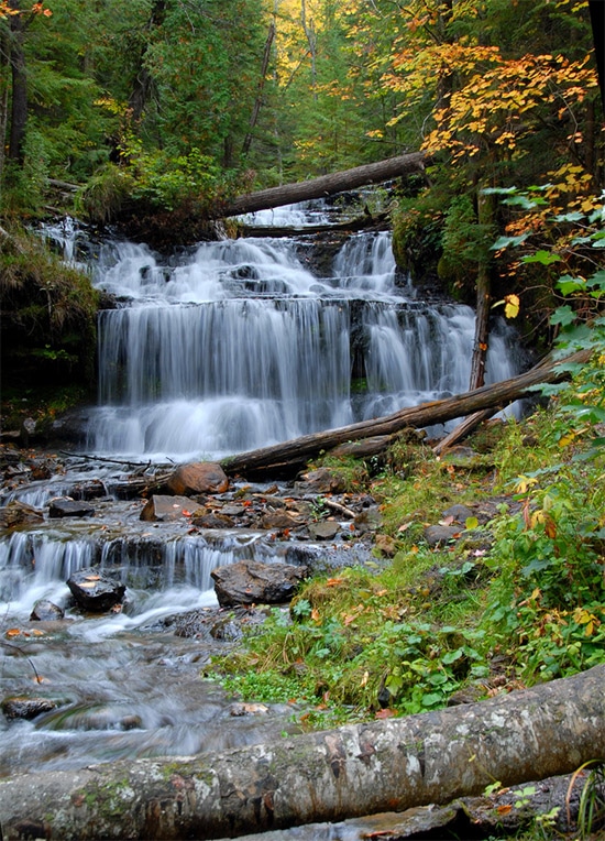
Wagner Falls by Jim Sorbie / CC BY 2.0
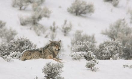
Sugarloaf Mountain
Sugarloaf Mountain is in Marquette on Michigan’s Upper Peninsula. The mountain could be the subject of your photographs, or it could provide an excellent view of the surrounding area. With just a short hike you can reach the top to get the views. County Road 550 serves as the starting point for the hike.

View of Sugarloaf Mountain by Zoe Rudisill / CC BY 2.0
Mackinac Island and Mackinac Bridge
The Mackinac Bridge spans the Mackinac Straight to connect the Lower and Upper Peninsulas. The suspension bridge can be the subject of your photos, and to the east of the bridge is Mackinac Island. This island is a popular tourist destination in the summer. The island can be accessed by ferry from both the Lower and Upper Peninsulas, and no motor vehicles are allowed on the island.

Mackinac Bridge by Dehk / CC BY 3.0
Charlevoix
Charlevoix is a town on the northernwestern part of Michigan’s Lower Peninsula. This town features some beautiful Lake Michigan shoreline, as well as Lake Charlevoix.
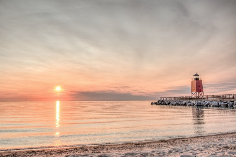
Charlevoix by Peter Ciro / CC BY-ND 2.o
Harbor Springs
Harbor Springs is about 25 miles from Charlevoix, also on the shores of Lake Michigan. It lies on the north shore of Little Traverse Bay. The Little Traverse Lighthouse at Harbor Point is one of the main things to see in the area, as well as beautiful lake and bay views.
Harbor Springs by Rachel Kramer / CC BY 2.0
Leelanau County
Leelanau County is on a peninsula at the northwestern side of the Lower Peninsula. It extends into Lake Michigan, and Sleeping Bear Dunes National Lakeshore is located in the county. This area is home to beautiful orchards, vineyards, and wineries. Leelanau State Park is located at the tip of the peninsula.
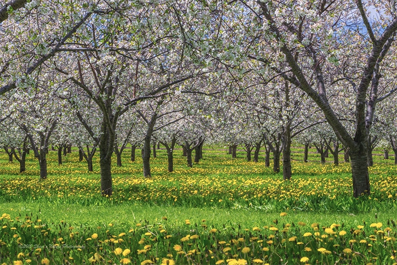
Leelanau County / © Sheen Watkins, used with permission
Belle Isle Park
Belle Isle is an 900-acre island on the Detroit River between the United States mainland and Canada. The park is managed by the city of Detroit and can be accessed by bridge. The island offers a conservatory, a nature zoo, and nice views of the Detroit skyline.
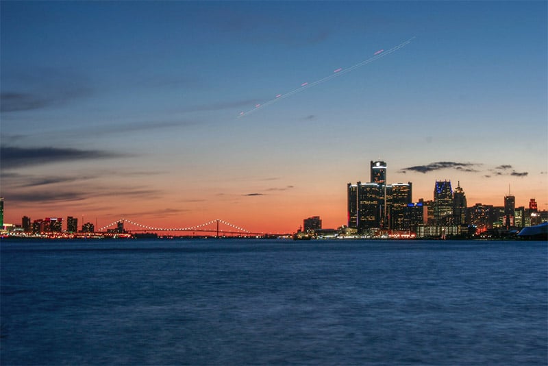
Belle Isle by Brian Kurtz / CC BY 2.0
Holland
Holland is in western Michigan, about 30 miles southwest of Grand Rapids. The city was founded by Dutch Americans and has maintained the influence of Dutch Culture. The Tulip Time Festival in May is a great opportunity for beautiful flower photography. It is also home to the Holland Harbor Lighthouse, also known as Big Red.

Holland by Brent Ozar / CC BY-SA 3.0
Grand Haven
Grand Haven is just 20 miles north of Holland, on the shores of Lake Michigan at the mouth of the Grand River. There is a nice lighthouse that is ideal for being photographed.
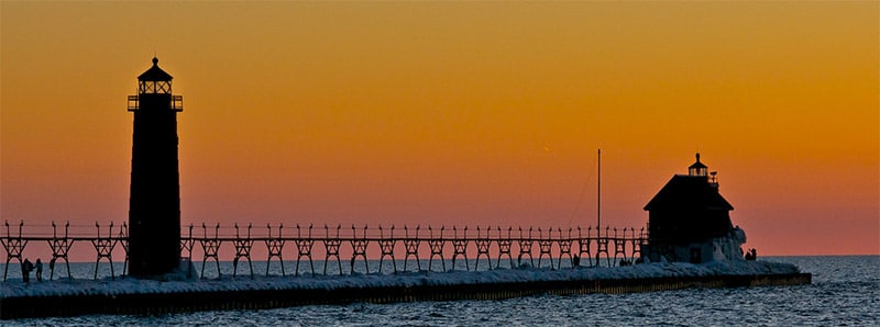
Grand Haven Pier by Chris Bunda / CC BY 2.0
Photo license links: CC BY-SA 2.0, CC BY 2.0, CC BY-ND 2.0, CC BY-SA 3.0, CC BY 3.0


Gorgeous photos, especially of the Sleeping Bear Dunes. Thanks for sharing these locations, guys, the interactive map helps so much! I’m with Explorest and we built an app that helps people discover 60+ beautiful photo locations in Michigan, and I think you’d enjoy it! We include the exact GPS coordinates & tips by the state’s best photographers. We also have locations in New York and California, across Asia and will be debuting in Europe soon. If you have a moment, check it out! https://www.explorest.com/
How about the numerous Metroparks in the Metro Detroit area? Kensington Metropark, Lake Erie Metropark, Oakwood Metropark, Stony Creek Metropark, Lower Huron Metropark, Indian Springs Metropark, Lake St. Clair Metropark…
Then there’s Pointe Mouillee State Park, Sterling State Park, Crosswinds Marsh Wetlands Nature Area, Howell Nature and Conference Center, Matthaei Botanical Gardens (Ann Arbor)… these are all excellent places for nature/landscape/wildlife/macro photography and are all worthy of inclusion on your map.