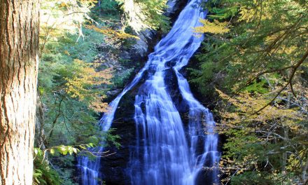
Canyonlands National Park by Chao Yen / CC BY-ND 2.0
Utah is a paradise for landscape and nature photographers. The many state and national parks are among the best in the United States, and even just driving through the state will allow you to see some amazing scenery. If you’re looking for places to photograph in Utah you will have no problem finding plenty of options. The biggest challenge you will face is deciding which locations to prioritize. This page showcases some of the best locations to photograph in Utah to help you plan your own trips. The interactive map below shows the location of each spot mentioned on this page.
This page will continue to be a work in progress, so please feel free to leave a comment with your own suggestions of great places to photograph.
Zion National Park
Zion National Park has an otherworldy feel to it. Located in southwestern Utah Zion is easily accessible from Las Vegas and the Grand Canyon. You’ll be able to photograph the canyons, sandstone cliffs, and the Virgin River that make Zion National Park so amazing. The are several noteworthy hikes that will take you to the best views in the park, but you can also get great photos by knowing the best places that are easy to access. See our guide to Photographing Zion National Park for all the details and recommendations.

Zion National Park by Diliff / CC BY-SA 3.0
Arches National Park
Located in eastern Utah near Moab, Arches National Park is home to amazing natural arches that are among the most amazing features of Utah’s landscape. The beautiful land forms, colors, and textures make Arches a perfect destination for photographers. The park is home to Delicate Arch, as well as more than 2,000 other arches.
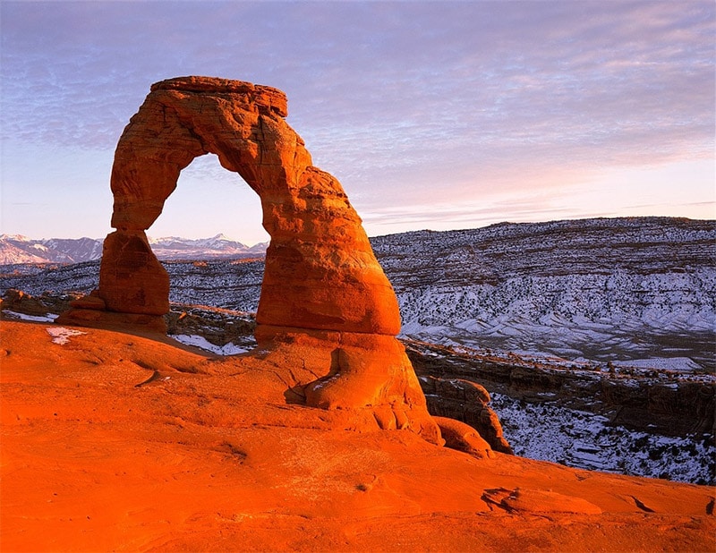
Arches National Park by Skeeze / CC0
Bryce Canyon National Park
Bryce Canyon National Park is located in southern Utah. Many people visit Zion and Bryce Canyon on the same trip due to their locations. At Bryce Canyon National Park you will be able to capture photos of the colorful hoodoos that make the park so unique. You’ll be able to get amazing photos of the fine texture and details, or use a wide angle lens and showcase the beauty of the amphitheater.
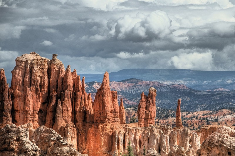
Bryce Canyon National Park by Ed Coyle / CC BY-ND 2.0
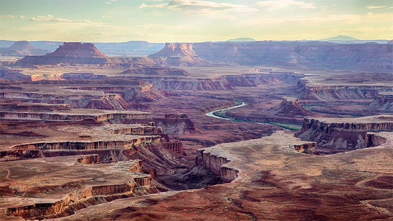
Canyonlands National Park
Canyonlands National Park is located in eastern Utah, south of Moab. It is very close to Arches National Park so you can easily visit both parks on the same trip. The park includes canyons created by the Colorado and Green Rivers. If you are going to visit Canyonlands planning is essential. The park is divided into four main districts, and no roads connect the districts. It can take several hours to drive from one area of the park to another, so be sure to research ahead of time and decide where you want to go. While it is not the easiest park to move around in, it is well worth the effort. Your photos will also likely be a little more unique than the more-frequently-photographed parks like Zion, Arches, and Bryce Canyon.

Canyonlands National Park by Chao Yen / CC BY-ND 2.0
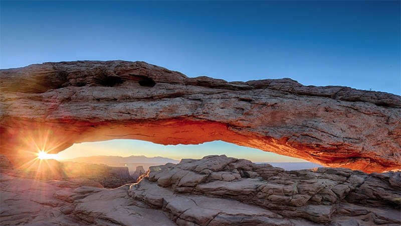
Mesa Arch, Canyonlands National Park by Chao Yen / CC BY-ND 2.0
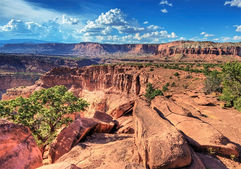
Capitol Reef National Park
Located in central Utah, Capital Reef National Park is roughly a two-hour drive from Bryce Canyon, Arches, or Canyonlands. The cliffs, canyons, red rock, white domes, and layers of stone will provide you with plenty of photographic opportunities. There is a scenic drive that offers the easiest access to views, and hiking trails can give you more unique views.
Capitol Reef National Park by Wolfgang Staudt / CC BY 2.0
Monument Valley
Monument Valley is located in southeastern Utah, right on the Arizona line. It is on Navajo Nation land and is one of the most recognizable scenes of the American southwest. The amazing sandstone buttes reach as high as 1,000 feet and there are plenty of possible vantage points for photos. You can pay an entrance fee to drive the 17-mile dirt road that will give you plenty of amazing views. Guided tours are the only way to reach certain parts of Monument Valley.
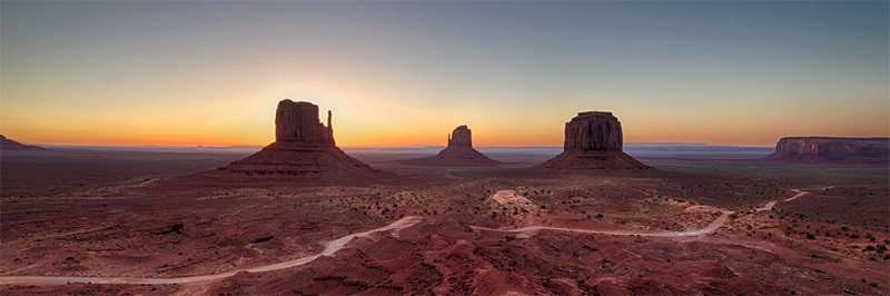
Monument Valley by Chao Yen / CC BY-ND 2.0
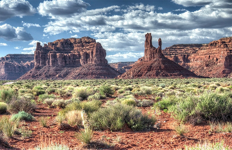
Valley of the Gods
Valley of the Gods is also located in southeastern Utah, just about a one hour drive from Monument Valley. Valley of the Gods offers similar rock formation, buttes, and mesas that you would find in Monument Valley. However, Valley of the Gods is not on tribal lands so there are fewer restrictions. There is a 17-mile road that winds through the valley (a 4-wheel drive vehicle is recommended). There are no hiking trails but you can wander freely and capture photos without crowds. There are no gas stations or services available in the area, so plan ahead and be prepared.
Valley of the Gods by John Fowler / CC BY 2.0
Glen Canyon National Recreation Area
The Glen Canyon National Recreation Area is a huge area (more then 1 million acres) the is bordered by the Grand Canyon, Vermilion Cliffs National Monument, Capitol Reef National Park, and Canyonlands National Park. This area includes part of Arizona, but it is mostly in southern Utah. One of the main points of interest is Lake Powell, which has more than 2,000 miles of shoreline. Lake Powell is one of the more unique and beautiful lakes in the U.S., and its close proximity to Las Vegas, Zion National Park, and the Grand Canyon make it very popular.

Lake Powell by PRA / CC BY 2.5
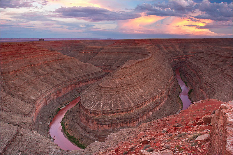
Dead Horse Point State Park
Dead Horse Point State Park is located in eastern Utah right next to Canyonlands National Park. It provides an amazing overlook of the Colorado River and a view into Canyonlands. The most noteworthy view in the park is of the gooseneck in the Colorado River, from a vantage point of more than 2,000 feet above the river. There are several other viewpoints in the park and a 9-mile loop trail for hiking.
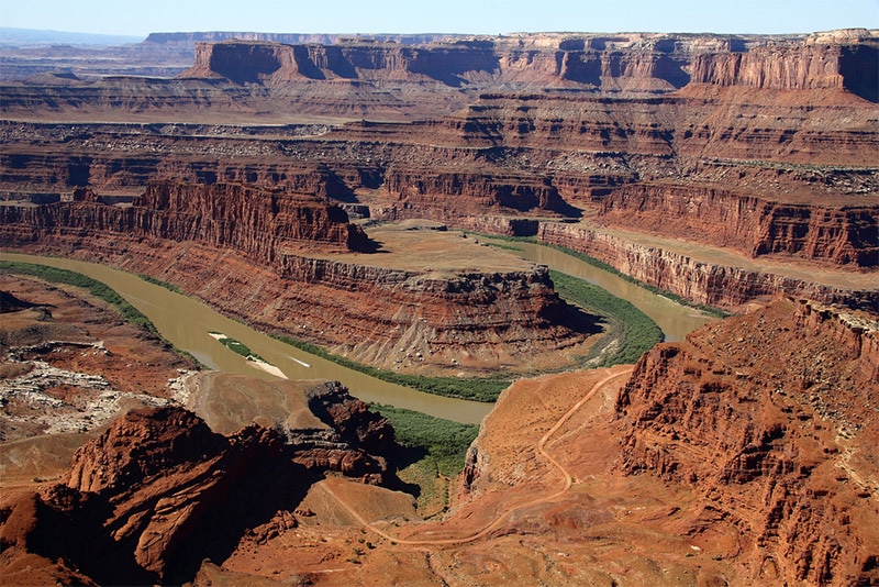
Gooseneck photographed from Dead Horse Point State Park by John Menard / CC BY-SA 2.0
Cedar Breaks National Monument
Cedar Breaks National Monument is located in southern Utah between Zion National Park and Bryce Canyon National Park. It features a 3-mile natural amphitheater that is more than 2,000 feet deep. Due to the high elevation of the park snow makes the area inaccessible for most of the winter. The visitor’s center is open June through October. The colorful rocks, bristlecone pines, and occasional wildflowers make for some great photos.
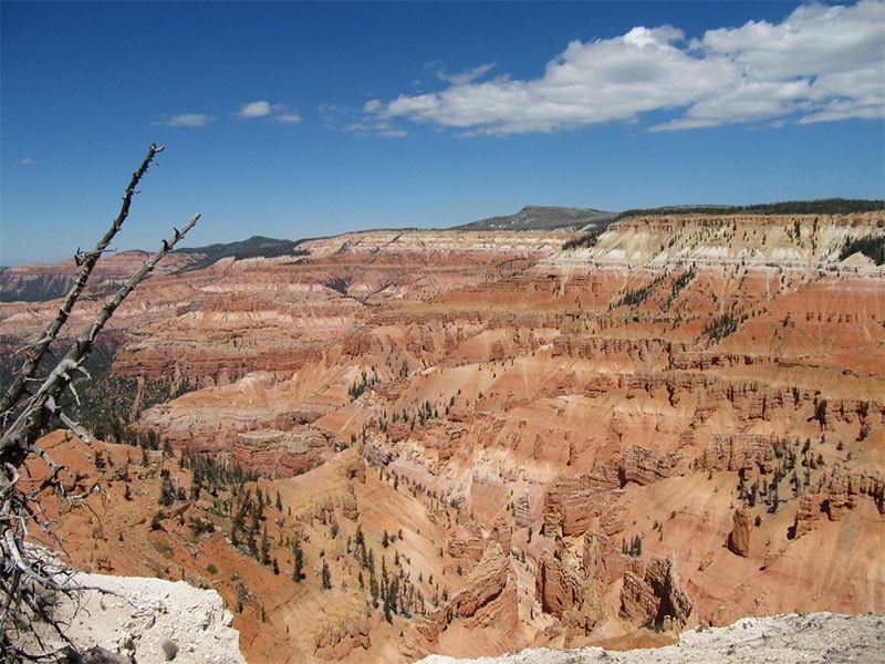
Cedar Breaks National Monument by ricketyus / CC BY 2.0
Natural Bridges National Monument
Located in southeastern Utah, south of Canyonlands National Park, Natural Bridges National Monument is home to the second largest natural bridge in the world. There are three natural bridges in the park, with Sipapu being the largest of them. Bridge View Drive will lead you to all three of the natural bridges, and there are trails that lead to the bases of each bridge. The park is recognized by the International Dark-Sky Association as having one of the darkest skies anywhere.

Sipapu Natural Bridge at Natural Bridges National Monument by Christian Mehlführer / CC BY 2.5
Rainbow Bridge National Monument
Rainbow Bridge National Monument is located in southern Utah, very close to the Arizona line. It is one of the largest natural bridges in the world with a span of more than 200 feet and a height of near 300 feet. It takes a little bit of effort to reach Rainbow Bridge. You will need to take a two-hour boat ride across Lake Powell from one of the marinas near Page, AZ.
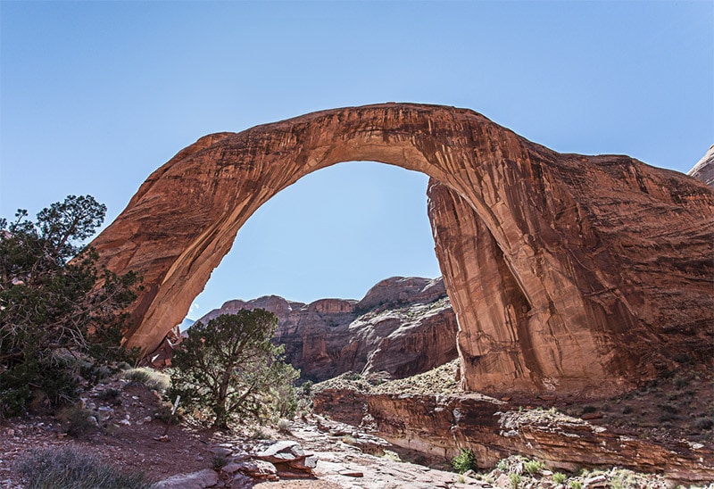
Rainbow Bridge National Monument by Andy Morffew / CC BY 2.0
Kodachrome Basin State Park
Kodachrome Basin State Park is located in southern Utah, just southeast of Bryce Canyon. The park is most easily accessed from the north. The most noteworthy feature of the park are the many sandstone spires, including Chimney Rock, that are just waiting to be photographed.
Kodachrome Basin State Park by Ken Lund / CC BY-SA 2.0
Goblin Valley State Park
Goblin Valley State Park lies in the San Rafael Desert and features countless hoodoos that give it a very interesting landscape. Hiking trails are available to see and access this unusual and beautiful park.

Goblin Valley State Park by Gleb Tarassenko / CC BY 2.0
Goosenecks State Park
Goosenecks State Park is located in southeastern Utah, south of Valley of the Gods. The park provides a view of the San Juan River from some 1,000 feet above. You can get a great view of two goosenecks where the river has carved through the land. This park includes no trails and no facilities (camping is allowed), but does provide a nice view for photos.
Goosenecks State Park by Stacy Egan / CC BY 2.0
Flaming Gorge National Recreation Area
Flaming Gorge National Recreation Area is located in northeastern Utah and southwestern Wyoming. The 90+ mile Flaming Gorge Reservoir is the centerpiece, and many different campsites and hiking trails are available. The red sandstone cliffs are the reason for the name “flaming”, and they provide for some dramatic photographs.
_23-9-2014_12-49-13.JPG)
Flaming Gorge by Paul Hermans / CC BY-SA 3.0
Antelope Island State Park
Located in northern Utah on the Great Salt Lake, Antelope Island State Park is a great place for landscape and wildlife photography. Not only will you have great lake and mountain views, but the park is also home to roaming herds of bison, pronghorn, big horn sheep, mule deer, and many birds. The island park can be easily accessed by a driving over a causeway from the mainland.
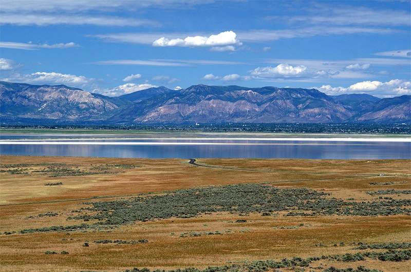
View of the Great Salt Lake from Antelope Island State Park by Maureen / CC BY 2.0
Coral Pink Sand Dunes State Park
Coral Pink Sand Dunes State Park is located in southern Utah, just a short drive from the east entrance to Zion National Park. The red sand dunes are very picturesque and a commonly used for recreational activities like off-roading. All of the park is open for exploring on foot.
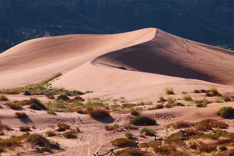
Coral Pink Sand Dunes State Park by werner22brigitte / CC0
Snow Canyon State Park
Snow Canyon State Park is located in southwestern Utah, west of Zion National Park. The Canyon is named after the Snow family (early Mormon settlers), not because of an abundance of snow. The park features the large sandstone canyon, as well as cinder cones and ancient lava flows. The road entering the park from the south leads you through the canyon and then up the eastern edge of the canyon.
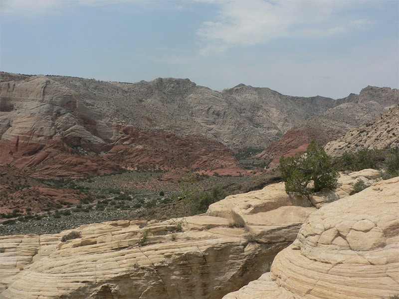
Snow Canyon State Park by Dylan Duvergé / CC BY 2.0
Bonneville Salt Flats
The Bonneville Salt Flats are located in northwestern Utah, very close to the Nevada state line. It is commonly used for racing, including land speed records. The area is extremely flat and barren. Visitors can freely access the salt flats (managed by the Bureau of Land Management), and you can even drive on it. The area makes for some unique photographs due to its distinct look.
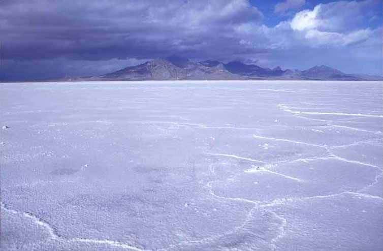
Bonneville Salt Flats by Bureau of Land Management / CC BY 2.0
Nine Mile Canyon
Despite its name, Nine Mile Canyon is actually 40+ miles long. What makes this canyon so unique is the amazing collection of Fremont and Ute rock art on the canyon walls (so much so that it is sometimes referred to as an outdoor museum). The area also includes some historical ranches and structures. Even aside from the history, Nine Mile Canyon has a lot to offer for photographers. It is located in northeastern Utah and is best accessed from the town of Price.
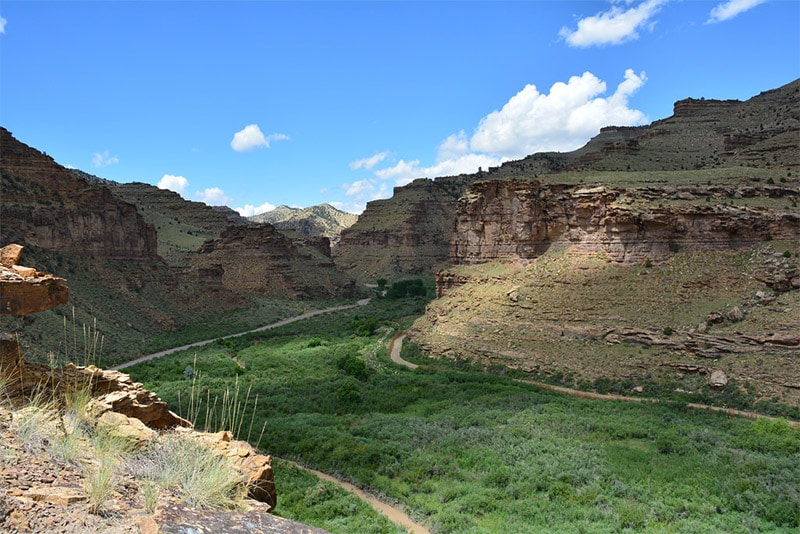
Nine Mile Canyon by Bureau of Land Management / CC BY 2.0
San Rafael Swell
The San Rafael Swell is located near central Utah, just a bit to the east. The swell, roughly 75 miles by 40 miles, is a giant dome-shaped fold of sandstone. It has been eroded to form canyons and gorges that are quite beautiful. Interstate 70 runs through the swell and is the only paved road access to the region. There are some dirt and gravel roads in the area, most were originally used for uranium mining. Goblin Valley State Park is located on the southeastern edge of the swell.
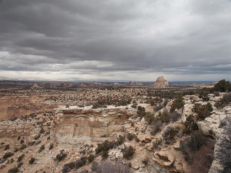
San Rafael Swell by Stanislav Sedov / CC BY 2.0
Paria Canyon
The Paria Canyon lies in northern Arizona and southern Utah and is part of the Vermilion Cliffs National Monument. Hiking in the beautiful canyon is very popular, but plan ahead because permits are required. The Wire Pass Trailhead is a popular starting point for hiking in the area.
Paria Canyon by Bureau of Land Management / CC BY 2.0
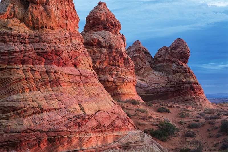
Grand Staircase-Escalante National Monument
The Grand Staircase-Escalante National Monument is a huge area (almost 2 million acres) in southern Utah. This area is actually larger than the state of Delaware. It includes Fifty-Mile Mountain, the Canyons of the Escalante, Coyote Gulch, Devils Garden, and slot canyons. Devils Garden features arches, hoodoos, and sandstone formations (located 17 miles southeast of the town of Escalante).
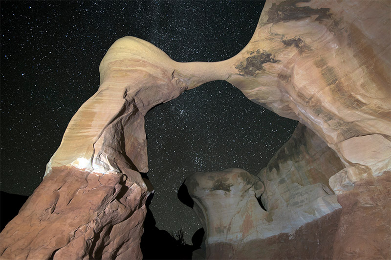
Metate Arch in Grand Staircase-Escalante National Monument by John Fowler / CC BY 2.0
If you’re having trouble deciding which amazing places in Utah to visit, consider this 7-day itinerary recommended at visitutah.com.
Want to learn more about neighboring states? Please see:
- The Best Places to Photograph in Idaho
- The Best Places to Photograph in Nevada
- The Best Places to Photograph in Arizona
- The Best Places to Photograph in New Mexico
- The Best Places to Photograph in Colorado
- The Best Places to Photograph in Wyoming
Photo license links: CC0, CC BY 2.0, CC BY 2.5, CC BY-ND 2.0, CC BY-SA 2.0, CC BY-SA 3.0